newspaper
agenda cultural
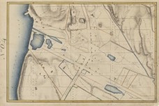
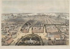
The Greatest Grid: The Master Plan of Manhattan, 1811-2011 celebrates the 200th anniversary of the Commissioners’ Plan of 1811, the foundational document that established Manhattan’s famous street grid. Featuring an original hand-drawn map of New York's planned streets and avenues prepared by the Commission in 1811, as well as other rare historic maps, photographs and prints of the evolution of the city's streets, and original manuscripts and publications that document the city’s physical growth, the exhibition examines the grid’s initial design, implementation, and evolution. The Greatest Grid traces the enduring influence of the 1811 plan as the grid has become a defining feature of the city, shaping its institutions and public life.
The exhibition is accompanied by a book of the same name, edited by Hilary Ballon of NYU, who also curated the exhibition, and co-published by the Museum and Columbia University Press.

Randel Farm Map No. 64, 1819 Used with permission of the City of New York and the Office of the Manhattan Borough President

C. Bachman, New York, View looking south from Union Square, 1849. J. Clarence Davies Collection, 29.100.1344

