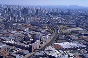
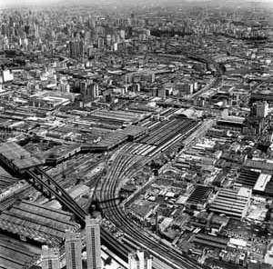

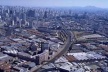
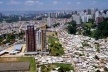
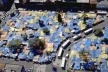


“Like a huge, dynamic mass of gridded patches and structureless emulsions of masonry, asphalt, cars and people, the colossus sprawls across the endless plateau and gobbles its way through the dark green forest, leaving little reddish spots behind. The new developments and the mutations follow the logic of land speculation and are driven by instantaneous impulses such as a randomly placed new factory or an equally randomly placed favela. Admittedly, the ring of motorways around and through the center, together with the railways and two rivers, form a bundle of infrastructure that allows us a distant panorama, and the built-up area occasionally follows an undulation of the landscape, but ultimately these nuances vanish amid the hugeness and chaos of the whole. Thus Sao Paulo has the appearance of a vast, monotonous, dense uplift cut across by deep clefts…Every notion we may have about planning and architecture evaporates here. What do you do about cities with over 10 million inhabitants? You cannot do them justice with ‘normal’ planning or ‘normal’ architecture. That would suggest that the contemplative slowness of the plan or design would work here. In Brazil, action is chronically overtaken by events. No time for consideration, no time for reflection. That’s a European luxury, but here every municipal organization is powerless against the proliferation of the city. All that can be done is to keep things under control. Urban planning becomes a matter of policing rather than a political or cultural discipline.”
Wim Nijenhuis & Nathalie de Vriers (2)
Fragments
This is an inquiry on some aspects concerning the incredible contradictions that are nowadays placed in the territory of Sao Paulo – the urban mutations – and also a discussion of some urban projects that work on these new challenges presented on the contemporary city. These urban projects work on the bordering conditions of the fragmented metropolitan territory: urban voids, wastelands, brownfields, terrain vague (3).
These strong mutations emerged in the post-industrial city, more emphatically after the restructuring of the spatial economy on the last decades. The industrial decline generated the emptiness of whole urban areas. The metropolitan territory became depository of huge transformations and wasting became particularly evident on the urban fabric today: underused industrial zones, warehouses and industrial yards; abandoned central buildings; storage yards; railroad corridors and railyards.
The presented urban projects were developed on the railroad corridor of Sao Paulo within all these territorial fragments and they work in close relation within the discussed concepts.
In this sense, a brief analysis about the territorial transformation process of the metropolis of Sao Paulo is also presented through some comments, numbers and images: an overview of the territory under mutation, a panorama of the fragmented and contradictory metropolis.
Sao Paulo Mutations
| Numbers | |
| Population | 17 million |
| Area | 1.509 km2 |
| Density | 11,600 persons per km2 |
| Contribution to GNP | 45% |
| % of Brazilian total population | 10,5% |
| Population growing | 0.5% per annum (5% during the 70´s) |
| Population in 1900 | 0,2 million (grew 27,000% in 100 years) |
| Population estimate 2015 | 20.7 millions |
| Urbanized area growing | 40,000% in 100 years |
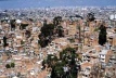
| % population living in favelas (shantytowns) | 20% (1.3% in 1973) |
| Metro network | 49.5 km (3.5 million passengers daily) |
| Rail network | 270 km |
| Bus transport | 11,000 units (3.5 million passengers daily) |
| Number of cars | 5.1 million |
| Murder rate | 35 per 100.000 |
Sao Paulo is nowadays a paradigm of the local metropolis in the global world. At just one time, a global city linked within the global network and a local city, where the banal space manifests itself as unfair and disqualified. It is, then, depository of an urban territory that faithfully portrays, with all contradictions of our time, the contemporary society: a “glocal city” (4).
We live in the accelerated transformation age. The territorial dynamics have never been so dramatically realized in the history of our cities. Architecture introduces itself in this context suffering mutations in all scales. The metropolis materializes in its fragmented territory the rupture and the urbanity lack.
The consequences of the post-industrial metropolis quickly transformations are several, heterogeneous and complexes. Disqualified spaces emerge in the city, old productive areas are waste: wastelands and urban dysfunctions appear.
Then, the architectural transformations are present in the territory scope and vice-versa (5).
Functions, uses and spaces have been transformed in the metropolitan territory through a dynamic and unexpected way. The perennial leaves for the transitory (6).
Historical configured environments loose their functions. Historical centres become exhausted. Industrial territories seem, suddenly, disqualified. Whole urban blocks are object of speculation into transformation.
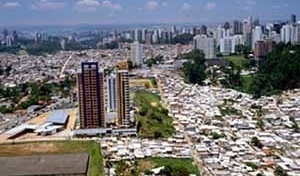
Forgetful spaces receive real estate development impulse. Luxurious residential areas emerge in the middle of the depreciated peripheries like the closed islands of walled villas in the midst of a territory without any kind of urbanity sense. Anti-cities – closed cities – emerge in between the fragmented territory.
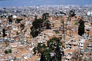
Environments under special protection are occupied and re-urbanized. The illegal city is added to the legal city: shantytowns appear on the mountains, hills and around lakes areas. The urban legislation is obliged to run after of the illegal reality: again, emerge the urban mutations.
At the same time, society gets into the New Century with a strong preoccupation about the environment preservation and about the recycle of the existing sources, natural and energetic. The environment transformation – on the territory and on the building scales – puts itself, therefore, inside this new demand: the sustainable development. It is more intelligent the transformation of the existing and non-used spaces instead of its substitution or denial.
In the city scope, we live the transformation moment of the existing territory, its restoration. Differently from other times, where the city transformation generated an urban renewal process under strong imposition (the tabula rasa prototype process) or the revitalization of historic centres into a fake urban scenario (the post-modernism prototypes of the 70´s and the 80´s), we have now a much more complex and rich situation.
Could the accelerated territory transformation be faced with local actions? In this sense, could the urban design still assist the rescuing process of huge deteriorated areas without creating scenic simulacrums?
On the other side, could the urban project be configured as an instrument to face the fragmented and disarticulated territory of immeasurable scale?
Finally: how could the urban project places itself facing the urban emptiness – the urban voids – without configuring itself as an oppression instrument, but first, as a real possibility of territorial rearticulation?
Minimal
The new dimensions that lies in this territory – the fragmentation, the retails, the de-articulation (the un-articulated territory), the wastelands, the fluidity and the flows´ network – are all presented at the territory of the railroad axis in Sao Paulo.
With the emptiness of the industrial occupation, the railroad loses very of its function. The lack of incentive to the railroad while a system of efficient and integrated public transport connected to the metro system, decisively corroborated for its emptiness of importance.
Its decay in the last decades also represents the spatial dereliction of its borders. A fragmented and deprived of characteristics territory was generated. The structures that had defined its occupation and consolidation today represent its obsolescence: the wastelands.
The architecture on the contemporary metropolis must have the plasticity that allows it to absorb the net of flows, the wastelands, and the new dynamics present in the disarticulated territory. Formal plasticity and programmatic flexibility are imperious in the contemporary urbanism (7).
The urban discontinuities and territorial fragments offer a new possibility of urban project: the construction of a new metropolitan territoriality.
The metropolitan residual areas should contain the new urban projects and should articulate the new territory spaces. The void spaces operate as a potential instrument for the construction of the new public space.
In this sense, we can think of the presence of the void in the urban fabric as a fundamental parameter on the contemporary dynamics in opposition to the common idea of the redevelopment of the wastelands in central metropolitan areas within a massive architecture presence. Sao Paulo needs an architectonic silence in opposition to the gray and dense built masse. The new program should appear just on the borders, facing the silence. The minimal.
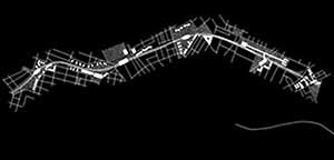
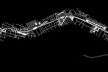
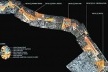
It is launched, then, an intervention strategy for a stretch of the railroad: a linear axis of 12.6 km extension.
It is established a dynamic urbanism through the urban matrixes system: four complementary urban matrixes that open the possibility of multiple designs through its many combinations. A new urban strategy, more flexible to the demands and the multiple programs of the contemporary metropolis. It is changeable in time and space. After all, the idea is about the establishment of an urban strategy that prepares the conditions for the construction of the territory. It prepares the territory to receive, coherently, the diverse urban programs and architectural elements, without, however, defining the final architectural forms.
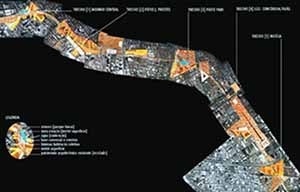
The four urban matrixes are:
1. Infrastructures:
It is configured for the reuse of the existing infrastructures and the optimisation of the existing field conditions: modernization of the railroad system and its transformation into a surface metro system; modernization of the existing stations and creation of new ones; reactivation of the non-used patrimony; recycling of the industrial areas into a new technological basis industry (industrial/services clusters and technopoles).
2. Flows:
It is configured through the combination of projects for the transports system – road, pedestrians and collective – which results in the flows optimisation in the metropolitan axle.
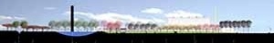
3. Green axis:
Throughout all territory, together to the railway line, appears a green axis, a linear metropolitan park, whose final image constitutes a green gradient that varies of density from the central body forest to its dilution in the territory: an urban forest.
4. Urban borders:
The consolidation of the great metropolitan public axle – the railroad axis as integrator of public activities mainly – will be possible within the implementation of the complementary program on the bordering territories: programmatic elements that respond to the forces of the surrounding neighbourhoods. Here is proposed the implementation of collective housing: affordable housing is an essential parameter on the process of reclaiming and renewing metropolitan wastelands.
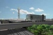
Void
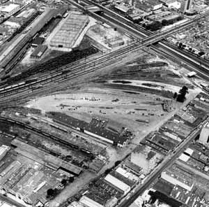
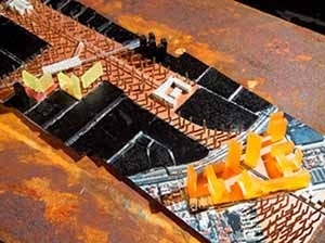
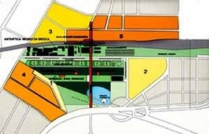
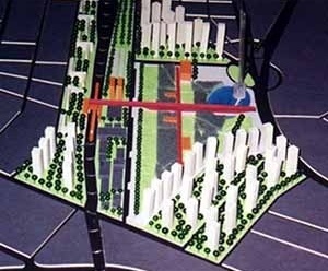
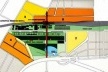
On the railroad axis, the Mooca/Antarctica area constitutes a typical urban void: an old industrial yard of 200,000 km2.
The general proposal of developing an “architectonic silence” here found its potential, opposing the common idea of imposing a massive architectural occupation in this urban island.
The strategy was to develop in the urban void a huge park with public program. A 400 meters esplanade connects the train stations and surface metro with commerce and leisure inside.
The old historical buildings of the Antarctica industrial complex were recycled and received cultural program.
On the borders were developed a proposal of varied collective housing and urban design, within commercial and leisure bases.
In resume: on the terrain vague, it is proposed the silence, the park within infrastructure connections. On the borders, appears the high-density collective housing (8).
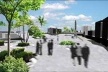
Connections
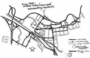
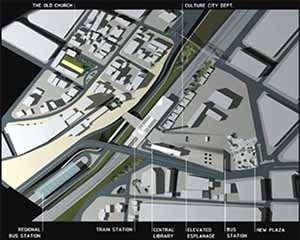
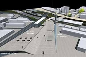
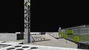
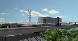
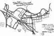
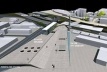
In the case of the Mauá city, southwest zone of the metropolis, the urban fabric is strongly determinate by the evolution of the industry that arrived on Great Sao Paulo and, parallel, by the presence of the old railway, nowadays partially deactivated.
The city downtown was historically installed close to the railway station, and through the city evolution, was swallowed by the massive industrial presence and by the commercial and residential occupation (50´s so on). That typical historic center – configured by the presence of the main Catholic Church, the Central Station and the Main Square – was abruptly transformed into an urban knot of extremely complexity. The residual spaces were accomplished by the informal commerce; the old public space was partially taken by the inconvenient presence of the Bus Terminal and an unpredictable pedestrian flow arise without the necessary spatial organization that allows the railway transposition. On the other side of the railroad appeared a new public activity pole, determinate by the presence of the modernity. The Urban Renovation Plan of 1975, developed by the famous Brazilian Architect Vilanova Artigas, established the Civic Center, as well as the railway transpositions and urban connections. Unfortunately, this original plan was just partially developed (9).
The situation diagnosis is nowadays of visible territorial disarticulation and fragmentation. The public spaces are deteriorated. There is no linking from one side to the other side of the railway. There are no connections through the public equipments.
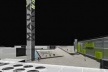
The urban rehabilitation project was configured from an urban general strategy: the rearticulation of the fragmented territory and an urban restoration process that rescue some important elements of the Artigas original plan (10).
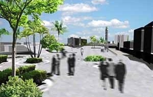
The policy is clear: to generate an urban catalyst element, an urban articulator element for the fragmented spaces. The proposals are: articulation and nodal integration of the public transports elements; to keep an “architectural silence” on the urban voids; to allow the public fruition and pedestrian flows; connection of the opposite urban nucleus; generation of an urban space with complementary uses and functions; the elevated esplanade connects all the architectural elements and links the 2 urban nucleus; the urban park appears as an articulation of the civic center nucleus, connecting the City Hall, the Forum, The Theatre and the new Sports Complex; to promote a general restoration of the public spaces through new urban and landscape designs; the rescue of the lost public dimension (presented in the Artigas original plan); to seal the historic centrality with important urban equipments, that is, to give new life for the historic center (central public library, sports complex and new stations).
Looking for setting free the urban ground with more flexibility and developing a new catalyst element connecting the different parts, the intervention also tries to rescue the best Brazilian urban modern principles into the contemporary city.
Surface inscriptions
The discussed works are paradigmatic of the huge contradictions today present at the territory of Sao Paulo. New urban equipments and urban regeneration processes operate as actors of a metropolis inserted in the global net, while the local space appears in the urban reorganization processes of the fragmented and disarticulated territory, illustrating the huge difficulties in solving the metropolitan’s problems of the periphery countries.
The metropolis under transformation reflects these complexities and present day projects of territorial “refunctionalization” can show new performing parameters. To give new functions to the deteriorated space is the alternative that the contemporary urban design can offer in opposition to some mistakes produced on the past decades post-modern processes of urban revitalization (more involved in creating urban scenarios).
The fundamental parameters of the correctly interventions here in Brazil should appear through the rigorous and critic geographical reading of the local territory: the surface inscriptions.
Urban interventions should work in absolutely proximity to the local demands, even of a global character, and always promoting the necessary social function of architecture. The local and urgent necessities should assist the urban programmatic interventions: an essential architecture and a not superfluous one.
The problem seems to be how to work on the existing city, when its territory has an immeasurable scale.
notes
1
This paper is originated from a lecture at the College of Architecture & Environmental Design, Cal Poly University, in 10/20/2003, called Building the Unfinished: Urban Design in Sao Paulo. All Sao Paulo aerial pictures are from Nelson Kon.
2
NIJENHUIS, Wim; DE VRIERS, Nathalie. Eating Brazil. Rotterdam: 010 Publishers, 2000.
3
To describe these kind of residual spaces presented on the metropolitan territory, the authors have used many different words. The definition of wasteland in its French origin, terrain vague, comes with accuracy in a text, currently classic, of the Catalan architect Ignasi de Solà-Morales under a cultural context: an area without clear boundaries, without current use, vague, of hard understanding on the collective citizens perception, constituting normally a tear in the urban fabric. But is also an available area, full of expectations, with strong urban memory, potentially unique, the space of the possible, of the future (SOLÀ-MORALES, Ignasi. Terrain Vague in: Anyplace, 118-123: Cambridge: MIT/Any, 1995.). The term urban void is quite used by many European authors and specially by the Dutch Architects (KOOLHAAS, Rem. Apud GUST. The urban condition: space, community, and self in the contemporary metropolis. Rotterdam: 010 Publishers, 1999.). In USA, the concepts of wastelands and, mainly, brownfields are more often used: “Often called “brownfields,” in contrast to “greenfields” at the urban edge, industrial wastelands comprise 5-10% of the metropolitan land area. It is estimated that there are at least 400,000 brownfield sites in the US, especially in the Midwest and Northeast. These are often situated within declining districts that have aging streets and other infrastructure. Their locations may be perceived as marginal, and they may be contaminated by decades of industrial use.” (SOUTHWORTH, Michael. Wastelands in the evolving metropolis. Berkeley: IURD/UC Berkeley, 2001, p. 8). Under an American approach, lots of information could be found at the Brownfield Source Organization (www2.brownfieldsource.org). Finally, it is interesting to see the pioneer approach developed by Kevin Lynch in 1981 (LYNCH, Kevin. Wasting away. San Francisco: Sierra Club, 1981).
4
SASKIA, Sassen. Scale and Span in Global Digital Word. In Anything, 44-48: Cambridge: MIT/Any, 2001 e RECAMÁN, Luis. New and Old Conflicts in Sao Paulo’s Urban (Dis) Order. In VRIERS, G. W. (org.) The global city and the territory: history, theory, critique. Eindhoven: TU/e, 2001.
5
SANTOS, Milton. The country distorded: the Brazil, the globalization and citizenchip. Sao Paolo: Plubifolha, 2002.
6
PEIXOTO, Nelson Brissac. Art/City: Group Urban Interventions: Brasmitte: Sao Paolo, Berlim. <www.uol.com.br/artecidade/cdf.htm>. Accessed in 30.08.2000.
7
ALLEN, Stan. Points and lines: diagrams and projects for the city. Nova Iorque: Princeton Architectural Press. 1999.
8
The work was developed by Carlos Leite and Mario Biselli architects in 2002
9
Vilanova Artigas: Projeto de Renovação Urbana de Mauá, 1975. Cf. Serviço de biblioteca e Informação da FAU-USP. Arquiteto Vilanova Artigas: Acervo Digitalizado. CDROM 04: Projetos de Urbanismo. São Paulo: FAU-USP, 2001.
10
The work was originally conceived by the Mauá Municipality team (Mariluce Rossi and team) and the final stage work was developed by GPA Architects (Mario Biselli; Carlos Leite; Artur Katchborian; Mônica Brooke and team).
11
The downtown Mauá urban intervention is based on an urban connections strategy, rescuing the fundamental idea of the 1975 Vilanova Artigas original urban renewal plan. An elevated esplanade connects the two sides of the railway, linking the historic centre and the modern Civic Area (City Hall, Municipal Theatre and the new Sports Complex and Sports Park). New public equipments were connected to the esplanade: Central Library; Municipal Bus Station; Regional Bus Station and Train Station. New urban and landscape design complements the work
about the author
Carlos Leite is Architect; M.Sc., Ph.D. [Sao Paulo]; professor at the Postgraduation Program in Architecture and Urbanism, Mackenzie Presbyterian University, Sao Paulo. He will be a Visiting Faculty Professor at the College of Architecture & Environmental Design, Cal Poly University in 2004.